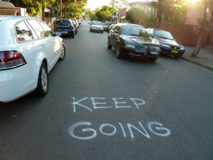
Keep going

Illawarra Road, Marrickville, NSW

Marrickville is an old suburb of Sydney and has narrow streets, particularly some running in a north-south direction, that are hardly adequate to function as the major thoroughfares they have become. Illawarra Road is like this. It’s a busy route linking the north side of the suburb to the Cooks River on the south side, and yet there are places where motorists travelling in opposite directions baulk at passing each other because of the tight space between the rows of parked cars on either side.

Someone has taken matters into their own hands on one stretch of Illawarra Road. If you are driving south there is a sign painted on the road that reads ‘Keep going’. If you are travelling north there is a longer sign that assures you that ‘2 cars can safely pass … please proceed’.

I am interested in what is really going on when people write their own rules and regulations on the pavement. In this case we can probably speculate that the person who painted these advisory notices is either a local resident who sees and hears cars stopping and starting outside their house all day, or a person who frequently uses this route and is often held up by timid drivers. What may to some extent may be an altruistic gesture, meant to assist motorists in negotiating this tricky bit of road, must also involve a large component of self interest.

Illawarra Road, Marrickville, near Sydenham Road.

Harbour Bridge resurfacing

In January 2012 Sydney Harbour Bridge is being resurfaced. Naturally I am interested.

The work is taking place over two weekends, or possibly three, depending on the weather. It is the first time in the Bridge’s 80-year history that the asphalt has been stripped back to the original concrete deck. Workers with small paint rollers on sticks will waterproof the deck with epoxy and large machines will lay a smooth asphalt surface over it. More about this on the NSW Government’s Transport website.

There were long traffic queues and cranky drivers on the first weekend as cars were diverted into the Harbour Tunnel. Presumably many people had not seen the mobile traffic signs and the advertisements that had been warning for months that the Bridge would be closed.  This weekend, after all the publicity about the delays last week, you’d think people would have got the message to take a longer route to cross the harbour. But apparently not, according to the Sydney Morning Herald. There were queues again today.

On Friday afternoon I drove over the Bridge some hours before it closed at 10.00 pm. My passenger took photos. To the left of the picture an electronic sign warns that the Bridge will be closed tonight. To the right you can see Lanes 1-3 have been newly resurfaced. The patchy asphalt on Lanes 4-6 is covered in graffiti for the instruction of the workers who will shortly be ripping it up.

Sydney Harbour Bridge partially resurfaced, 20 January 2012

The year in asphalt

All around the world the pavement has a symbolic role as well as a functional one so that, for example, during natural disasters or mass acts of civil disobedience broken asphalt is often invoked in words or pictures to depict the havoc created. Similarly, news services and bloggers publish images of pavement stains to represent the unpublishable and they scan pavement graffiti to capture the feelings of ‘the person in the street’.

Here, then, is a chronological catalogue of major news events of 2011 as told via the medium of the pavement. None of the images in this blog post is mine. I wasn’t there; I was too busy hunched over in my computer corner getting on with the Pavement Graffiti project.

 Queensland floods

“One of the few silver linings to the devastating Queensland floods could be an eventual stimulus to the economy as major repair work begins … It is still a matter of some conjecture as to which individual companies might profit. One likely candidate is Boral, which has market-leading positions in asphalt and other material for road.” (The Age, Melbourne)

 Cyclone Yasi in Queensland

Cyclone Yasi“That stretch of asphalt you see there, buried under the remains of the beach? That’s the Bruce Highway, the main (and virtually only) road to communities up the coast, and the main tourist town of Cairns. It will be a long time before Queensland has recovered from this.” (Must Use Bigger Elephants blog; ABC News, Australia)

 Earthquake, tsunami and nuclear meltdown in Japan

“Workers told how the earthquake ripped through the plant, immediately knocking out the main power. A ghastly boom was heard in the suppression chamber of reactor 4, said Kenji Tada, who was there at the time. Cracks started ripping in the asphalt and the sides of the building. They fled before the tsunami arrived and did its worst.” (The Telegraph, UK)

 Christchurch earthquake
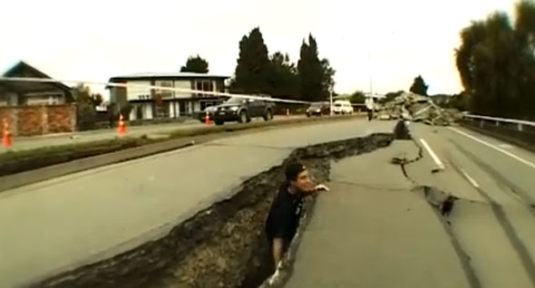
“This is the closest I have seen to skating in post-apocalyptic world, which is my fantasy.” (Skateboarding magazine.com)

 Osama bin Laden killed

“Days after Osama bin Laden’s demise, America’s burning concern—the most urgent outstanding question, at least according to Google search trends—had nothing to do with al Qaeda, terrorism, or torture. No, the death of the world’s most-wanted man has the country thinking about something else entirely: how to get buff. ‘Navy SEAL training’ followed closely by ‘Navy SEAL workout’ were the only bin Laden-related search terms in the Top 10 … SEAL training is the most ferocious workout in the free world … The best are eventually tapped for the elite Seal Team Six—the squad that got bin Laden … On the ‘grinder’, a black asphalt courtyard, would-be SEALs spend hours doing mass calisthenics. In the pool, they are ‘drown-proofed’ by swimming with bound arms and legs. On the shore, they experience ‘surf torture’ …” (The Daily Beast, USA)

 Cadel Evans wins the Tour de France

“ ‘Relief, for sure,’ says Cadel Evans’s mum, describing what is was like to watch her son on TV during the early hours of Sunday finally set himself up to become the first Australian to win cycling’s Tour de France.” (The Australian; Herald Sun)

 Explosion and massacre in Norway

“Blood smears the pavement, as a victim is treated outside government buildings in the centre of Oslo, Friday July 22, 2010, following an explosion that tore open several buildings including the prime minister’s office, shattering windows and covering the street with documents.” (WHAS11.com; AP photo)

 Riots in England

“After the rioting every night this week, the news headlines told a bleak story of communities under attack. But hours later locals wearing wellies and washing up gloves were reclaiming the streets with brooms, bin bags and dustpans … The main problem was broken glass from shopfronts … The hardest thing was cleaning up the remains of burnt-out cars … A community is forged on shared values. So, it’s understandable that local residents are keen to mobilise for a clean up, says Tony Cassidy, a psychologist at the University of Ulster … the immediate urge is to remove the damage that resembles an ‘ugly stain’ on their neighbourhood.” (BBC News Magazine)

Royal wedding

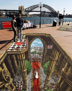
“To encourage more Australians to visit the UK British street artist Joe Hill has created dazzling 3D image showing the iconic Royal Wedding of Princess Catherine and Prince William. The bird’s eye view of Prince William and Princess Catherine’s nuptials can actually be seen on a Sydney pavement.” (Prince William Wedding News blog)

 Steve Jobs dies

“Ahmed Shafai, of Palo Alto, writes ‘Steve, you made our lives easier’ on the pavement outside the Jobs home in Palo Alto, California” (BBC News World)

 Occupy Wall Street

“In a tense showdown above the East River, the police arrested more than 700 demonstrators from the Occupy Wall Street protests who took to the roadway as they tried to cross the Brooklyn Bridge on Saturday afternoon. The police said it was the marchers’ choice that led to the enforcement action. ‘Protesters who used the Brooklyn Bridge walkway were not arrested,’ Paul J. Browne, the chief spokesman for the New York Police Department, said. ‘Those who took over the Brooklyn-bound roadway, and impeded vehicle traffic, were arrested’. But many protesters said they believed the police had tricked them …” (New York Times)

 Muamar Gaddafi is overthrown and killed

“In Benghazi, on the main square where it all started, they were slaughtering camels in celebration … And in the cafes, people were watching TV pictures – more graphic than any shown in Britain – of a bloodied Gaddafi dragged along and beaten, feebly protesting, before a gun was put to his head. The picture then cut to the dead ex-leader being rolled onto the pavement, blood pooling from the back of his skull.” (The Telegraph, UK)

 Protests in Egypt continue

“Fresh clashes erupted in Cairo between police and protesters demanding the end of military rule … A pitched battle between hardcore protesters and armed riot police has been going for five days straight. The fight turned a few-block radius of downtown Cairo into a virtual war zone. Police and protesters formed ever-shifting battle lines delineated by torched-out car skeletons and blackened sheets of corrugated metal, along a street littered with broken bottles and chunks of asphalt.” (Global Post)

 Leveson Inquiry into the phone-hacking scandal

“Sheryl Gascoigne, the ex-wife of former England footballer Paul Gascoigne, is now giving evidence to the inquiry … Gascoigne says journalists who followed her ‘hoped I would give birth on the pavement’ … She is speaking about the effect of the media pursuit had on her family. She says it was especially tough on her children, who often could not go out and play.” (The Huffington Post, UK)

 Conference on Global Warming, Durban

As the year neared its close this conference gave commentators the opportunity to trot out a collection of familiar pavement metaphors.

 “Perhaps it was Yogi Berra, the great baseball player, who best summed up the results of the latest fraught round of climate talks … ‘When you come to a fork in the road,’ he said, ‘take it.’ For the past two years, ever since the disappointing Copenhagen climate summit, the 194 negotiating nations have stood indecisively at just such a junction. In one direction leads a steep and rugged pathway to a global agreement – legally binding on developed and developing countries alike – to cut emissions of the greenhouse gases that cause global warming. In the other lies a gentler and more beguiling roadway, paved with voluntary measures and good intentions, which looks like leading to an ultimately hellish climate.” (The Telegraph, UK)

“Durban Platform Paves Way for Global Climate Treaty by 2015 … By the end of the meeting, the Durban Platform for Enhanced Action was agreed to by 190 nations …  In addition to a roadmap for a more comprehensive climate treaty, the EU and nine other nations also pledged to take new emission reduction targets under the Kyoto Protocol …” (Carbon Capitalist)

 Occupy Wall Street movement continues

“Yep…  Occupy pavement…  Works for me…  What a lost cause…  I have news for these idiots:  Wall Street never missed a step.  And they were up there in their glass towers looking down and laughing.  Absolutely wasted effort on the part of these street people…” (Burton Blog)

Not a good note to end on, I’m sorry. But to all my readers, thank you for your support and encouragement. I hope the coming year is a fulfilling one for you.

Megan
Politics

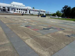
It is a warm Sunday afternoon in October, and we are on the forecourt of Old Parliament House – now called the Museum of Australian Democracy. The air is thick with fluffy seeds from Canberra’s avenues of exotic trees. In some places they lie in the gutters like drifts of snow. But despite the pleasant weather there is that sense of manicured desolation here that sightseers from other cities find remarkable about the national capital.

Perhaps it is not fair to judge the scarcity of people on this particular day. Potential visitors to museums have probably all been sucked away to the other side of Lake Burley Griffin where Floriade, the annual spring festival, is in full bloom.  We have chosen to avoid the flower beds and ferris wheels and instead are standing on the best example of pavement graffiti in the Australian Capital Territory.

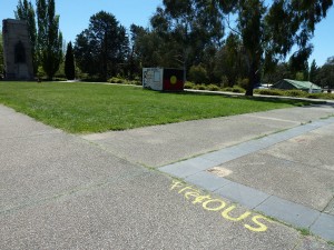
The controversial Aboriginal Tent Embassy was originally established on the lawns of Old Parliament House in 1972, claiming to represent the political rights of Australian Aboriginal people. After being removed several times it has now been in place since 1992. There is an official Aboriginal Tent Embassy website, and you can also read a potted history on Wikipedia.

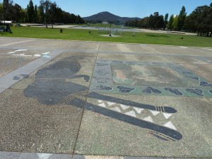
Today the tents and decorated sheds appear to be empty and all that there is to see are signs and flags, piles of firewood and a smear of smoke from the smouldering sacred fire. And of course, the decorated forecourt. Around its edges there are recently painted slogans and symbols, but mostly this expanse of paving is crowded with a worn menagerie of animals and plants painted in imitation of various styles of Aboriginal rock-art.

In their book Inscribed landscapes archaeologists Bruno David and Meredith Wilson draw parallels between Indigenous rock markings and graffiti. What better place than here at the Aboriginal Tent Embassy to reflect on their contention that all inscription, including modern graffiti and contact-period rock-art, is about the politics of turf. Inscriptions, they maintain, colonize space.

Wilson Street

When I posted a photograph of an embellished ‘bicycle route’ stencil in Little Eveleigh Street , near Wilson Street, back in March 2010, I suggested that the bike rider with a giant penis was not simply a joke but an expression of tension between local residents and the ‘greenies’ who cycle through on the way to and from the city.

It seems I was not wrong. The battle between cyclists and locals has escalated in this neighbourhood. In August 2010 I posted another photo from Wilson Street, this time a verbal blast: Eco-cycle rapists. This week on a walk through Darlington I found another angry notice, still readable even though it has been hashed over:  Attention bike Nazis no entry!

Wilson Street is a long back street stretching from Redfern Station to Newtown Station, and passing through Darlington and MacDonaldtown on the inner-city fringes of Sydney. It has been undergoing change for some years. Its corner shops have become art studios; Sydney University threatens to engulf it as it devours real estate to the north; and along the street’s southern side the former Eveleigh Railway Workshops – which would have provided employment for many residents of the little terrace houses in years gone by – have been turned into a theatre and arts centre. ‘Gentrification’ is the name of the street drama that is being performed here daily.

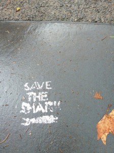
Whenever I visit Wilson Street it never fails to provide me with material for my pavement graffiti collection. This week, not far from the warning to cyclists, I noticed a worn little stencil in the middle of the road: Save the shark. According to other bloggers it’s been there a few years.

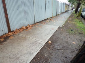
Near the ‘CarriageWorks’ cultural centre, some fairly recent wet concrete scratchings include an Aboriginal flag. In the background of this photo you can see the Skippy Girls painted on the corrugated iron fence.

Elephants on parade

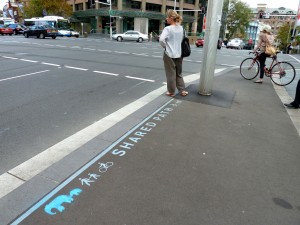
Shared path, College Street at Whitlam Square, Sydney, 2011


The relationships between cyclists, motorists and pedestrians are fraught and while some people are pleased with the new cycle lanes and shared pathways being installed by the City of Sydney, others are not. So it’s nice to see that some people have managed to keep their sense of humour.  Congrats  to the anonymous stenciller for this embellishment of a sign on the corner of College and Liverpool Streets, and thanks to the good sports in the Cycling Strategy department at the City of Sydney for drawing it to my attention.

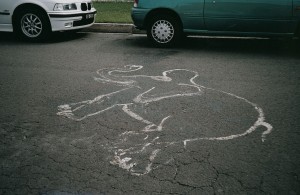
And while pondering the similarities (if any) between an elephant’s thick skin and the wrinkled greyness of the asphalt, I thought I’d dig out a couple more pavement pachyderms from my archives.

Elefant Traks music label, King Street, Newtown, 1999

Asphalt elephant, Queens Parade, Wolllongong, 2003

Names set in concrete

In some of Sydney’s older municipalities the names of streets and parks were once set into the concrete footpaths. Reminders of a time when people got about on foot more regularly than they do now, some of these still exist around the suburbs. On this footpath in Chatswood, for example, the name ‘Lawrence Street’ appears to have been pressed into the concrete while it was wet.

Other examples are more elaborate. In parts of the former Municipality of Petersham (that is, Petersham, Lewisham and Stanmore) the name is embedded in the paving slab in contrasting red concrete. When one of these slabs gets broken you can sometimes see the wire formwork that holds the lettering in place.

Although many have been broken or mutilated over the years, local councils have begun to recognise the heritage value of these concrete names. The Marrickville Heritage Study of 1984-86, for example, lists street names on footpaths and kerbing as interesting examples of the type of works undertaken in the old Municipality of Petersham, adding that the remaining examples help to define the character of the area.

Despite the recent interest in preserving them, I have had some difficulty in obtaining specific information about how and when these pavement embellishments were originally made. However I did find from the Haberfield Conservation Study, prepared for Ashfield Council in 1988, that ‘blue and white enamel street name signs and red cement lettering of street name signs let into the footpath were … distinctive features’ of the model suburb of Haberfield developed by entrepreneur Richard Stanton between the years 1901 and 1922.

It seems likely that the Petersham street names came somewhat later. Now incorporated into the Marrickville local government area, the Municipality of Petersham was established in 1871. In 1929 its Council took out large loans to commence a program of paving its roads with concrete and replacing its asphalt footpaths with concrete at the same time.  These types of works became a major part of a program to provide employment for men during the Great Depression of 1930-1937.

By 1948 Allan M. Shepherd’s book The Story of Petersham was able to boast that “today only a very small proportion of the total length of all the footpath paving of the Municipality is not of concrete” and that “there are no unmade roads, lanes or footpaths, and every thoroughfare is in good condition”. Shepherd’s book does not mention the concrete street names specifically, but it is safe to assume that the making of these was included in that great concreting project of the 1930s.

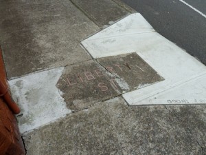
For several years I have been monitoring a badly cracked ‘Liberty Street’ name in the footpath on the corner of Cavendish Street, Stanmore. In May 2010 I thought its days were numbered when I saw sprayed marks on the footpath indicating that Marrickville Council was going to construct a pram ramp on the kerb.

However some months later I found that the rectangle of old concrete bearing the name had been saved, although it was surrounded by incongruously white modern concrete and a straight cut had been made in it so that it could conform to the slope of the ramp.

Maps

At this point in my Pavement Graffiti project I’m thinking about maps – the formal and the informal, the fanciful and the accidental.

Two lovely books that I ordered arrived on my doorstep this week. The first is Kris Harzinski’s From here to there:  a curious collection from the Hand Drawn Map Association. It contains the kind of mud maps that people draw for one another on the back of an envelope or on a page torn from a notebook. Harzinski is just as interested in the story behind the map as he is in the map itself. But he doesn’t use the term ‘mud map’. It was only while researching this blog post that I realised that this term, which I use from time to time, is Australian in origin.

The second book is The map as art: contemporary artists explore cartography by Katharine Harmon. There are 360 works reproduced here. Described on the back cover blurb as ‘a collection of visionary topographies and imaginary geographies’, these artworks are executed in many different media. Two I particularly liked featured map-like marks on the ground: Nina Katchdourian’s Moss Maps are ‘scrambled atlases’ of lichen on granite rocks; the Rock Maps of eight-year old artist Theodore Lamb are photographs of cracks in rocks.

Lamb’s Rock Maps remind me of photographs I have taken of cracks in asphalt. They show up best after rain and this ‘map’, taken in Stanmore (Sydney), even includes a sky-coloured lake.


Last year I photographed a wonderful map drawn by a boy on the footpath outside his house in Rozelle. His play world grew each day.

Feet

I’m sitting in a specialty shoe shop trying on different pairs and moaning about my crook feet. The shoe fitter says that it’s all because of the hard surfaces we walk on and goes on to tell me a slightly garbled story about this tribe of people in Africa who still go everywhere barefoot. I am inclined to think that people who habitually walk barefoot are not confined to Africa but I don’t say so. He’s doing his best to make me comfortable.

It is an annoying irony that I should have a fixation about photographing pavements and the writing on them, and yet I often have trouble walking any distance at all. In fact, when I took photographs of the Olympic marathon line remnants on Sydney Harbour Bridge, I was in a wheelchair. My daughter valiantly pushed me because I didn’t want a recent foot operation to prevent me taking part in the 75th Anniversary
Bridge Walk in 2007.

Wilson Street, Newtown, June 2008

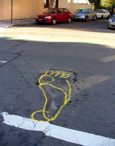
Anyway, today’s photograph is dedicated to two distinct lots of people: those who always walk barefoot, wherever in the world they are; and the workers who maintain our roads and footpaths (and who sometimes have a joke when they are marking potholes that need repairing).

Island hoping

Since this blog has become something of a travelogue, I should write about Lord Howe Island, which I visited recently although it is not an ideal destination for someone hoping to study pavements and pavement graffiti.

A few facts and figures then. Lord Howe is a World Heritage island paradise located some 600 km east of the Australian mainland. Nearly all the roads on the island are sealed but there are only 10 km of them. There are very few kerbs, gutters or paved footpaths. The speed limit for the 100 or so motorized vehicles on the island is 25 km per hour, consequently there are hardly any street signs except for one or two Stop signs and several warning about Mutton Birds on Road and Woodhens on Road.

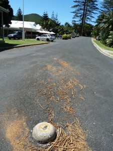
I kept an eye out for graffiti and traffic marks on the bitumen itself but found none. Well, almost none, except for one upside-down-pudding-bowl ‘silent cop’ (correct terminology: traffic dome) at the
T-intersection of Lagoon Road and Ned’s Beach Road, and some
angle-parking spaces marked out nearby.

The only other pavement embellishment I found was an exceedingly flat rat on the road outside the Museum (close-up view omitted in deference to the squeamish). Rats came to the island off the wrecked ship Makambo in 1918 and promptly set about making at least five native bird species extinct. Rat control measures have been in place since then. Although not totally successful, these measures are probably more efficient and certainly less random than squashing by car.